
Falls Township Previous Residents by Era
Falls Township previous residents are best traced by matching the question to the period. The Bucks County Recorder of Deeds supplies the recorded land trail, while the Board of Assessment supplies the current parcel bridge. Historic Fallsington, Bucks County Free Library, and the Mercer Museum add local maps, papers, directories, and archival county records. None of these sources alone establishes every person who lived at an address. A deed identifies parties to a transaction, and a census identifies a household at its enumeration date. Used together, they make a defensible address history.
| Record source | Verified period | Access point | Address-history use |
|---|---|---|---|
| Recorder and LANDEX | 1684 to present | Recorder, LANDEX, or Mercer index | Recorded parties, dates, instruments, and legal descriptions. |
| Board of Assessment | Current weekly feed; no historic start stated | Public Access portal or counter | Parcel, current record context, values, sales, and map links. |
| Historic Fallsington collections | Deeds 1794 to 1927; maps 1849 to 1974; phone papers 1908 to 1929 | Appointment or paid research | Local family, map, deed, telephone, and place context. |
| Bucks directories | 1860, 1871, 1894, 1902, and 1914 verified editions | Library and genealogy routes | Post-office, business, township, or defined citizen-list context. |
| Federal census | Released under the 72-year convention | BCFL, library databases, and archival routes | Household evidence for the stated census date. |
| Township permit material | Historic cutoff not verified | BS&A, Code office, or focused RTKL request | Dated construction or alteration evidence where retained. |
Start a modern property trail with the exact situs address or parcel number, then confirm the current record with the Recorder if a change may be recent. For a nineteenth- or early-twentieth-century question, pair the Recorder path with Historic Fallsington or Mercer. The county directory editions are useful checkpoints, not a continuous annual roll. A catalog entry is an access lead, not proof that the underlying item is online.
Falls Township Address Records Before 2012
The Recorder’s party indexes are the core evidence for previous residents who owned the land. They are arranged in historic bands: 1684 to 1919, 1920 to 1941, 1942 to 1951, 1952 to 1963, 1964 to 1971, 1972 to 1979, 1980 to 1988, 1989 to 1993, 1994 to 1998, and 1999 to present. Older groups are not purely alphabetical. After July 1, 2012, documents receive instrument numbers instead of book and page citations. A missing book/page on a later record is normal.
The LANDEX Webstore provides General, Instrument Number, and Book/Page search modes for Bucks County records.
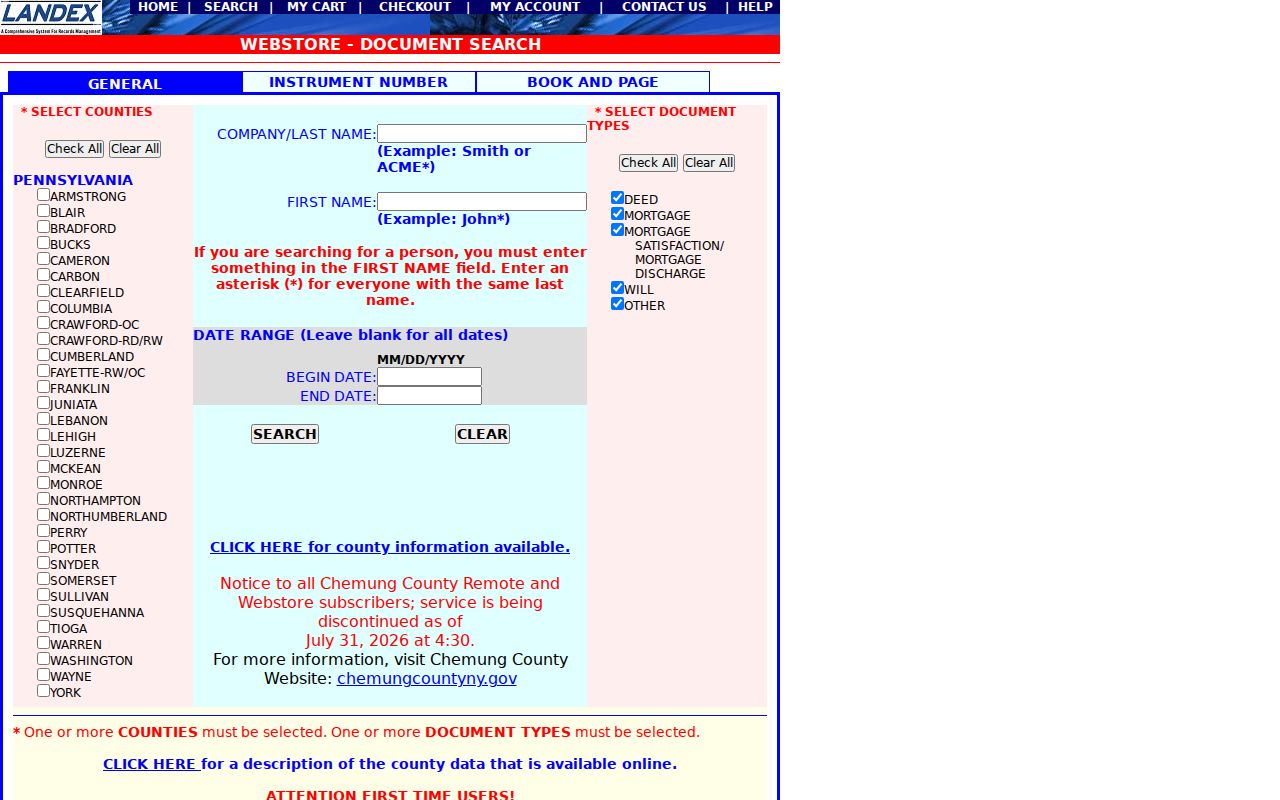
General search accepts a company or last name, first name, begin and end dates, and selected document categories. Bucks County and a document category are required. An asterisk or question mark can help with a name variant, but the result ceiling is 250 name matches. Instrument and Book/Page modes require exact identifying information and do not accept wildcards. Browser orders are paid, include a processing charge, and are not a certified-copy channel. The Recorder counter, phone, and mail route remain available when a copy or older index work is needed. Supply the name, property location, approximate year, and parcel if available. Recorder staff can demonstrate the index, but they do not perform title or historic research.
Note: Preserve both the old book/page or newer instrument number with the date, because the citation format identifies the correct search path.
Falls Township Previous Residents Deed Trail
The deed chain answers who held title before the current owner. Begin with the Board of Assessment’s owner, address, or parcel route, then use the owner’s purchase instrument in the Recorder index. The legal description is the key continuity check. A street address can change in style, and a similar name can point to the wrong person or lot. The legal description or parcel number ties one transfer to the same land across the backward trail.
- Find the exact Falls Township situs address or parcel number in Assessment Public Access. Record the displayed date and distinguish the situs from any mailing address.
- Find the current owner’s purchase instrument through the Recorder’s Direct or Indirect Party index. Capture the recording date, citation, prior party, and legal description.
- Search the prior seller as an earlier buyer for the same legal description. That earlier purchase leads to the preceding transaction.
- Repeat the sequence backward, carrying the parcel and legal-description clues through every link. Move into the appropriate historic index band when the date changes.
- Use the Recorder research area, mail-copy route, or Mercer’s historical index when the paid web route or an older book leaves an unresolved gap.
- Direct Party
- Bucks County’s label for a grantor or seller, and for a mortgagor or borrower in a mortgage record.
- Indirect Party
- Bucks County’s label for a grantee or buyer, and for a mortgagee or lender.
- Chain of title
- The ordered sequence of recorded transfers connecting the current land interest to earlier parties.
- Legal description
- The deed or plan language that identifies the land conveyed. It is more reliable than an old address label for separating similar parcels.
Assessment data refreshes weekly and can lag a recorded ownership change. For a current transaction, contact Assessment about a discrepancy and confirm title at the Recorder. The parcel map is useful for location and boundaries, but it does not replace either of those official sources.
Bucks Direct and Indirect Party Terms
Bucks County uses Direct Party and Indirect Party where many researchers expect grantor and grantee. That difference matters when tracing past residents through property. A seller in one deed is often the earlier buyer to search in the preceding transfer. Mortgages use the same directional pattern with borrower and lender labels. Recording the role beside each name prevents a chain from being walked in the wrong direction.
Use a short source grid for each event: searched situs address, parcel number, map date, assessment result date, party role, recording date, instrument number or book/page, legal-description reference, and any mismatch. This is especially useful where the same surname appears repeatedly. A tax correspondence address may help identify a record, but it is not evidence that someone lived at the Falls Township property.
Note: The property trail becomes stronger when each party, parcel, date, and legal description agrees across independent County records.
Falls Township Previous Residents and Census
Previous residents are not always previous owners. After a land trail identifies a time period, use directories, census schedules, newspapers, obituaries, and probate records for household context. The verified Bucks directories are selected editions rather than an annual Falls run. Their descriptions support post-office, township, business, and defined list information, but not an assumption that every resident appears. The Falls Township city directory collections provide the documented repository paths without turning those scattered volumes into a continuous address list.
- Write down the date range from the recorded transfer and search under Falls Township, Fallsington, Fairless Hills, or Levittown when the period calls for a historic label.
- Locate a directory edition or library resource close to that range. Capture the edition title, page or image, spelling, locality wording, and every address-like detail.
- Pair the directory year with the nearest available federal census. Treat the census as household evidence only for its enumeration date.
- Use newspaper or obituary material to corroborate an event or locality, then check the Register archive for a probate or estate record when that is the relevant question.
BCFL offers Ancestry Library Edition, HeritageQuest, and Power Library access, subject to current library and card rules. Mercer’s archival county series are not online, but its research library offers onsite and paid remote research. An obituary or directory mention is a lead to test, not a substitute for the recorded property chain.
Falls Township Address History in Fallsington
Historic Fallsington is the strongest distinct local archive for an older Falls Township address. Its appointment-based collection includes local deeds and legal material from 1794 to 1927, maps from 1849 to 1974, Falls Rural Telephone Company papers from 1908 to 1929, Friends genealogy, meeting minutes, family papers, photographs, and local newspapers. It charges prepaid research fees and its physical holdings are not a general online database. A precise family or place request is more useful than a broad request for everyone at an address.
Historic Fallsington’s collection overview describes the local materials and research access available for Fallsington.
Those records supply place and family context around an address. They should be paired with the Recorder’s legal record rather than used to assert a full occupancy sequence. The Fallsington materials are also a reason to search alternate locality terms, especially for a property whose later records use Fairless Hills or Levittown.
Postwar Labels in Falls Township Records
Historic labels can make a Falls Township address look missing when it is merely cataloged differently. Falls Township dates to 1692, but its postwar record context changed sharply after Fairless Works was announced in 1950. Construction began in 1951, full production followed in 1953, and more than 9,000 homes were built from 1950 through 1970. Fairless Hills and Levittown therefore matter as search terms for postwar maps, papers, directories, and local records.
There is no verified Township street-renumbering project in the research record. Do not invent one when an address search fails. Try the street name without a number, an older place label, a parcel, a plan, or a legal description instead. Differences such as Highway versus Hwy are search-format variation, not proof of a renamed street.
Note: Test historic place labels one at a time, then confirm municipal and parcel details before adding a result to a house history.
Falls Township Previous Residents Permit Trail
A Township permit can date work at a property but does not identify a complete household. Falls uses the BS&A route for permit applications. For a defined address and date range, a focused request can seek an application or permit number, application date, work description, plans, inspection or final outcome, applicant or agent, and related zoning decision. Historic coverage, export behavior, and a complete searchable archive were not verified.
The appropriate fallback is a specific written request to the Township under the Pennsylvania Right-to-Know Law process, not a request for an answer to an open-ended history question. Pennsylvania Right-to-Know Law, Act 3 of 2008, 65 P.S. §§67.101–67.3104, calls for a request for identifiable records. Township material can supplement a recorded title chronology by marking construction or alteration dates.
Falls Township House History Limits
Use Falls Township previous-resident research for family history, house history, heir questions, property curiosity, or verifying a suspicious property filing. It should not be used to track a living person.
Records can be incomplete, later than an event, or limited to a particular role. A deed records parties to land, a permit records property work, and a historical directory or census record belongs to its own date. No single result establishes a current household.